When Brunswick Exploration Inc released initial drill results on April 25, 2024 for its winter drill program at Mirage I was taken aback by the nature of the disclosures which seemed to suggest that Mirage was shaping up to be little more than a mirage. What struck me as odd was that although Brunswick drilled 35 holes during the winter program, I could only count 22 holes on the drill plan the company provided. And except for the 4 holes for which assays were reported, none of the other new hole locations had numbers. Since the company follows the practice of numbering holes in the sequence drilled following the prior year's holes, which totaled 36 holes, I expected to see holes #37-#71 on the map. On the assumption that holes are logged and shipped for assaying in the order completed, I was surprised that the press release included assays for holes 49, 57, 58 and 60. What were the results for 37-48, 50-56 and 59? Were they blanks or very short intervals or low grades, with the result that Brunswick only reported 4 holes, of which #57 and #58 were not exciting at all? Fortunately Brunswick's CEO Killian Charles did return my call and provided plausible explanations for the strange appearance which has left me bullish that when the final results arrive over the next month or so the scale of Mirage will have increased from last year, with plenty of further growth left when drilling resumes in July.
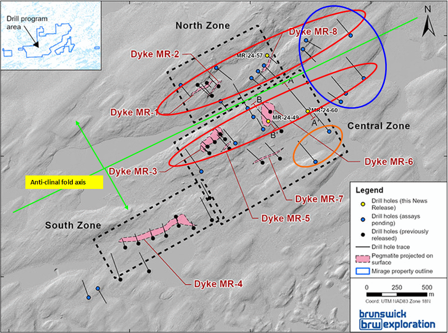
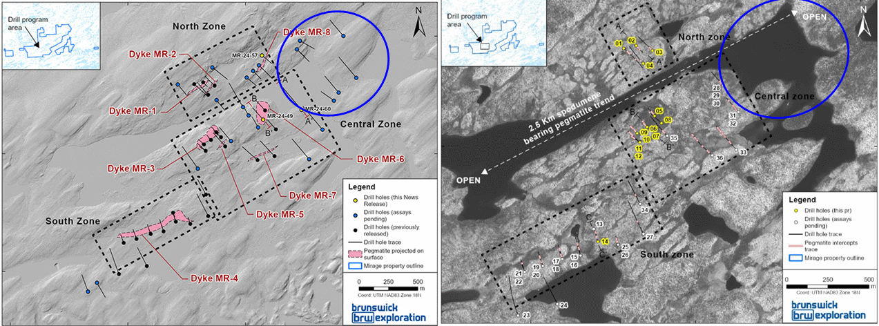
First off, the 22 drill holes marked on the drill plan map are actually drill pad locations, some of which had several holes drilled at different angles but in the same direction. This makes it impossible to show the traces since they stack on top of each, which is why we saw only one drill hole trace per "pad". They did not number the holes not yet assayed because it would have made the drill plan far too busy. The "hole" pattern we see is complete.
They also had two rigs until the end of March, and although they are following last year's numbering sequence (ie last hole is #71), we could not infer anything from the numbering in terms of what they were seeing in the field and responding to as far as which pad the rig goes to next. A rig may have problems with a hole while the other rig has none, and since they are drilling in different areas the numbering sequence reveals no information as would be the case when a company is using a single rig as a vectoring tool probing the third dimension and deciding on that basis where to drill next.
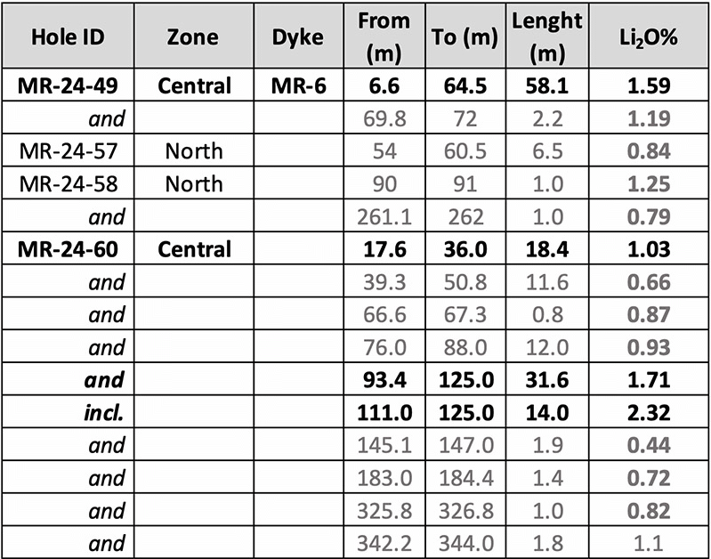
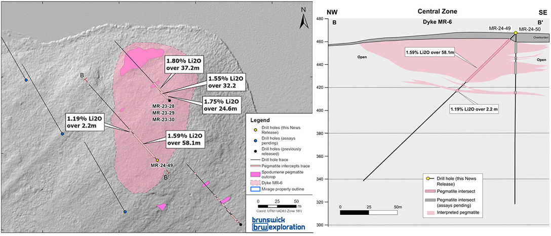
With regard to why assays were reported first for holes 49, 57, 58 and 60, they had some logistical issues with the shipping order, so that it is not a case of first drilled first assayed. However, #60 which steps 250 m northeast of last year's MR6 dyke limit at the boundary of the inlier claims optioned 75% from Electric Elements and for which Brunswick recently bought out the 0.5% royalty Sirios Resources Inc acquired when it sold those claims to Virginia Mines, was important and I believe was given priority. The reason it was important is that they wanted to chase the MR6 dyke northeast by drilling through the ice. There is a narrow northeast oriented lake which has bulges at the southwestern and northeastern ends which makes it look like a barbell. As it turned out, winter was warmer than expected, and the drill crew's efforts at ice thickening never achieved a comfort zone.
The 6 holes within the area I have highlighted with a blue circle are within the inlier claims and ended up being drilled from shore. This batch of holes are the most important in terms of expanding the scale of the discovery because it extends the strike of the "central" zone (MR3 & MR6) 1 km to the northeast. Killian resisted my efforts to tease out confirmation that drilling in this direction was successful beyond #60 which had two intervals of 18.4 m at 1.03% Li2O and 31.6 m of 1.71% Li2O, but in the next sentence he was talking about the outcrop 3 km to the northeast on 100% owned ground which is on dry land that can be drilled during the summer. If the dyke is confirmed under the lake they will consider barge drilling this summer.
He has also confirmed my conclusion that they see the lake separating the "north" and "central" zone has an anticlinal fold axis for what was once a continuous dyke but which has now been split into north and south limbs, with the north limb dipping north and the south limb dipping south. The southern limb has a shallow dip, so those holes I have circled in orange are potentially important. With regard to the 200 m gap between MR 3 and MR6 which each have a small stepout fence of holes, the reason they did not infill this gap was because it can be drilled during the summer. The focus during the winter was to test targets where access during winter is easier.
When I talked to Bob Wares at VRIC in Vancouver he was dismissive of geophysics as useless for targeting pegmatites, including gravity which Winsome claims has been very helpful. He still is of this view, but Killian told me that in late January they started doing gravity and that the area drilled by #60 has a gravity low, so the team is of a different opinion from Bob. The test will come later this summer when they tackle the barbell at the southwestern end of the lake which has a similar shape to that at the northeastern end on the inlier claims where I have my fingers crossed about those 6 holes in the blue circle. And it has a similar gravity low anomaly. A skeptic like Bob would argue that lakes distort gravity data and the correlation of the dyke with a gravity low is just coincidence.
When Killian mentioned they were eager to test the southwestern barbell this summer because of the gravity low, I pointed out that the most recent map they published showing the location of outcrops and boulders shows nothing down ice from this target. Killian explained that this area is largely overburden covered but they did find spodumene bearing boulders, just not giant ones like within the 3.5 km train of micaceous pegmatite I have circled in green.
As far as this 3.5 km boulder train is concerned, the last two holes of the season are those southwest of the "south" zone (MR-4 dyke) and were drilled in opposite directions as scout holes at what is the head of the micaceous bolder train. Killian would not say what was hit, but elsewhere in our chat he declared they still have not intersected pegmatite or sampled outcrop whose mineralogy explains that of the micaceous boulder field. The mystery of its origin will be given a hard look this summer, and remains a potential blockbuster discovery.
As far as weather is concerned, although this was a warm winter and the geese have started heading north early, causing the Cree to scramble to get in position for the annual goose hunt, unlike last year this has been a typical moist winter. While things can still go dry in May and June, the risk of huge forest fires is lower this year. One issue is that in some locations where the peat caught fire these fires smoldered through winter. But the authorities are aware of these locations and are monitoring closely for flareups. Brunswick expects to report assays for the remaining holes in bigger batches during May and plans to have boots on the ground in June to further prospect Mirage after getting kicked out last year in early June due to fire closures, with drilling at Mirage to resume in July for what promises to be a very busy exploration season. |